Ireland is one of those places that I’ve always wanted to see, but for whatever reason I just never had the chance to go.
My wife and I were deciding on where to go for our 20th anniversary, and after much discussion we settled on the west coast of Ireland. We wanted a trip where we could escape for a couple of weeks, go on some long hikes without any particular focus, and just generally wander (sans kids!). And let me tell you: there is nowhere I’ve ever been that ticks these boxes as well as The Wild Atlantic Way.
After a small hiccup with lost luggage from our flight into Dublin, we jumped into our rented Renault Clio and headed northwest to Donegal, with a short detour through Northern Ireland. The first thing that hits you about driving in Ireland – aside from the right-hand drive cars, which I was used to having driven a bit in the UK and Barbados in the past – is the INSANELY small roads. Couple that with the crazy high speed limits on those insanely small roads, and you’ve got a recipe for stress. Fortunately, you get used to it all fairly quickly.
Donegal is lovely and *super* rural (which, again, is what we wanted). So many sheep. We took a 4 hour hike on Slieve League, which was capped off by an incredibly windy time on one of the many peaks. So windy, in fact, that I was a little bit afraid of being blown into the Atlantic. All’s well that ends well, though, and we made it back down in time to catch the last shuttle bus back to the car.
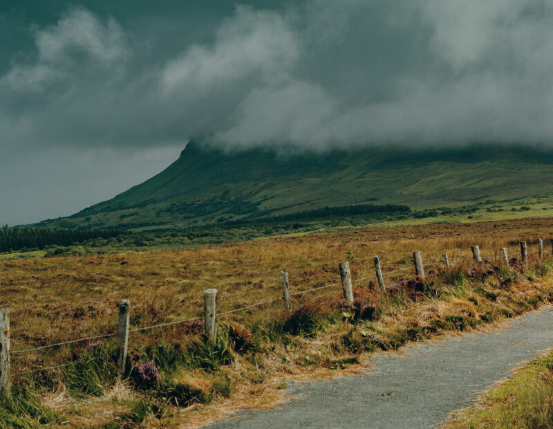
After Donegal, we drove down to Clifden in County Galway. This was one of the most incredible drives I’ve ever had the good fortune to do (as an aside, I’ve had a GREAT driving year, having also done almost the entire Highway 1 drive from San Francisco to San Diego – albeit it in two different stints). Driving through Connemara is something very, very special, and you’re absolutely blown away by the sheer size and remoteness of everything. Just an incredible experience. We hiked the route around Benbulbin on our way down to Clifden; another gorgeous experience.
After arriving in Clifden, we had a lovely seafood meal and a rest, followed the next day by a 6 hour hike of Diamond Hill (the upper loop). This was a special experience. Again, the scope and scale of the valleys and hills cannot be adequately described. It was simply breathtaking. Lots of tiny gnats or some other kind of tiny insect at the summit, but that didn’t spoil a lovely day.
From Clifden, we drove down to Doolin in County Claire. On our way, we stopped in Galway to take a day trip to the Inishmore in the Aran Islands. After a ~1h ferry journey, we arrived on Inishmore and rented bikes to see the island. The winds were up that day, which made things a bit more difficult than usual, but we managed to see a large portion of the east coast of the island, from the ferry docks out past the beach (complete with several beachgoers, despite the cold temperature and wind), all the way to Dún Aonghasa, which provides incredible views over the Atlantic (if you can get over the vertigo induced by the very sheer cliffs).
After the Aran Islands tour, we made our way down to Doolin. This is the closest town to the famous Cliffs of Moher, otherwise known as the Cliffs of Insanity (“Inconceivable!”). Doolin is a picturesque village right on the coast, with lots of little shops and restaurants to serve the large number of tourists who use the town as their base camp for exploring County Claire and the Cliffs of Moher.
Unfortunately, my wife got sick with (probable) food poisoning on our first night in Doolin, so she had to miss the Cliffs of Moher hike the following day. The hike itself is fairly easy, compared with what we’d done the previous few days. But the vistas are superlative; views out into Galway bay to the Aran Islands, with Inisheer – and its famous lighthouse and shipwreck – clearly visible in the distance. It’s clear why the Cliffs of Moher are amongst the most population attractions in all of Ireland. After a walk out as far as Hag’s Head (the official end of the Cliffs), I made my way back to the visitor centre (about a 90 minute walk back) and waited for the bus to take me back to Doolin.
With my wife still feeling the strain of her food poisoning, we made our way down to Kenmare in County Kerry. Kenmare was by far the largest town we stayed in on the entire trip (which isn’t saying much…Kenmare really isn’t very big). This was our base to explore the magnificent Ring of Kerry, including the Kerry Cliffs, Skellig Michael (where Luke Skywalker lives, apparently), and Ireland’s highest peak: Carrauntoohil. The normal route for cars is to drive clockwise around the ring, starting and ending in Killarney. However, because we started in Kenmare, we decided to go out as far as St. Finian’s Bay and then take a more interior route through the Iveragh Peninsula. This was absolutely a high point of the trip, and not just because it was literally the high point of the trip. The mountain range known as MacGillycuddy’s Reeks lie in this area, and the views are absolutely breathtaking. Our poor little Renault’s clutch didn’t completely love the constant up and downshifting on the numerous switchbacks through this region, but we made it through, emerging at Moll’s Gap (just in time for a bathroom break and a nice ice cream cone).
From Kenmare, we drove back to Dublin for our flight home the following day. A 10-day whirlwind, for sure. But oh what a trip! Definitely a life-changing experience.


